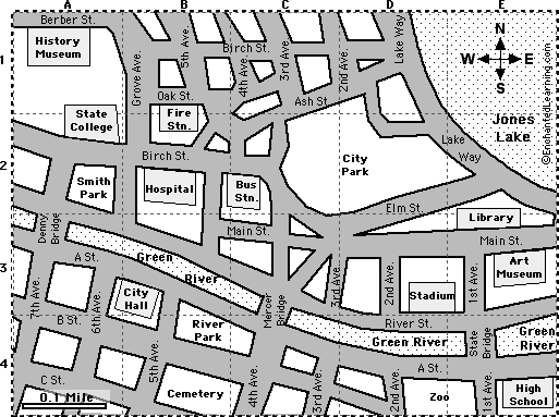
| 1. Color the map as follows: Blue-water, Red-fire station, Orange-museums, Yellow-stadium, Green-parks, Pink-city hall, Purple-hospital, Brown-cemetery. |
2. Draw a green "X" at the intersection of C Street and 6th Avenue. Draw a black "X" where River Street meets State Bridge. Draw a blue "X" at the address 650 A St.
|
| 3. In red, draw a short street route from the library to city hall. |
| 4. Which bridge is closest to the Art Museum? |
_____________________ |
| 5. Which is farther north, River Park or City Park? |
_____________________ |
| 6. How far (in miles) is it from the bus station to the hospital? |
_____________________ |
| 7. If you cross Denny Bridge going north, turn right at River St., turn left at Grove Ave., turn right at Oak St. and walk half a block, what building do you see on your right? |
_____________________ |
| 8. What park is located in A2? |
_____________________ |
| 9. When you look north, you see the river. When you look east, you see the High School. Where are you? |
_____________________ |