Advertisement.
EnchantedLearning.com is a user-supported site.
As a bonus, site members have access to a banner-ad-free version of the site, with print-friendly pages.
Click here to learn more.
(Already a member? Click here.)
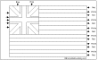
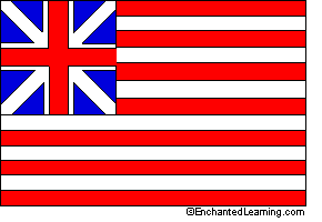 The Grand Union flag was an early US flag that was officially adopted by the Continental Congress in 1775. This flag was first flown in December, 1775, by the Colonial fleet of ships in the Delaware River. On land, it was first flown on January 1, 1776, at George Washington's headquarters near Boston, Massachusetts, when General Washington took command of the reorganized Continental Army.
This red, white, and blue flag featured 13 red and white stripes (representing the 13 colonies) and pictured a small British Union Jack flag in the canton position (a small square on the top, by the flag pole). This flag represented the Continental Congress for two years, after which it was replaced by Old Glory (the predecessor of our modern flag, featuring 13 stripes and 13 stars).
Related Pages:
USA: Label Me! Printouts
Label many maps of the USA. |
United States of America: Zoom School
Use a pictorial interface to get information on the USA, including maps, flags, animals, explorers, fossils, a quiz, and printouts on the USA. |
USA State Facts, Maps, and Symbols
A page on each US state listing facts, map and symbols (each one with links to map and flag printouts/quizzes). |
US Regions: Map/Quiz Printouts
Over 50 map printouts: read a map and answer questions about it. |
Enchanted Learning®
Over 35,000 Web Pages
Sample Pages for Prospective Subscribers, or click below
Click to read our Privacy Policy
Enchanted Learning Search
|
Search the Enchanted Learning website for:
|
Advertisement.
Advertisement.
Copyright ©2002-2018
EnchantedLearning.com ------ How to cite a web page