EnchantedLearning.com is a user-supported site. As a bonus, site members have access to a banner-ad-free version of the site, with print-friendly pages. Click here to learn more.
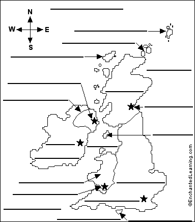
Atlantic Ocean - the body of water in which the British Isles are located Belfast - the capital of Northern Ireland Cardiff - the capital of Wales Celtic Sea - the sea south of Ireland Dublin - the capital of Ireland England - the largest area in the United Kingdom; it is attached to Scotland and Wales Edinburgh - the capital of Scotland English Channel - the body of water off southern England which separates it from France Hebrides - islands off the northwest coast of Scotland Ireland - (the Republic of Ireland) - a country west of England across the Irish Sea (not part of the United Kingdom) Irish Sea - the body of water that separates England and Ireland Isle of Man - an island in the Irish Sea Isle of Wight - an island off the southern coast of England London - the capital of England (and the capital of the United Kingdom) North Sea - the body of water northeast of the British Isles separating it from northwestern Europe Northern Ireland - a part of the United Kingdom bordering the Republic of Ireland on the northeast Orkney Islands - islands off the northeast coast of Scotland Scotland - a part of the United Kingdom bordering England on the north Shetland Islands - islands far off the northeast coast of Scotland Wales - a part of the United Kingdom bordering England on the southwest

 Atlantic Ocean - the body of water in which the British Isles are located