
|
| You might also like: | Outline Map North America | N Label Me! Printouts | Outline Map Rivers of North America | Rivers of North America Label Me! Printout | Label New Jersey Map Printout | Today's featured page: Flamingo Printout |
| Answers | Label North America |
Geography Printouts |
|
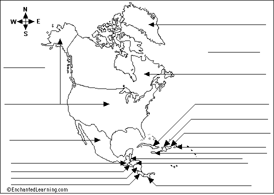
Atlantic Ocean - the ocean east of North America. Belize - a country in Central America at the southeast border of Mexico and northeast of Guatemala. Canada - the second-largest country in the world - it is north of the USA. Costa Rica - a country just north of Panama. Cuba - an island country in the Atlantic Ocean off the southeast coast of the USA. Dominican Republic - a country located in the eastern part of the island southeast of Cuba (it is east of Haiti). El Salvador - a country in Central America that is south of Guatemala and Honduras. Greenland - an island in the Atlantic Ocean northeast of Canada. Guatemala - a country in Central America south of Mexico and west of Belize. |
Haiti - a country located in the western part of the island southeast of Cuba ( it is west of the Dominican Republic). Honduras - a country northeast of Nicaragua. Jamaica - an island country in the Atlantic Ocean south of Cuba. Mexico - a country southwest of the USA and north of Guatemala and Belize. Nicaragua - a country just north of Costa Rica. Pacific Ocean - the ocean west of North America. Panama - a country at the southernmost tip of Central America. Puerto Rico - an island in the Atlantic Ocean east of the Dominican Republuc. United States of America (USA) - a country north of Mexico and south of Canada. |
| Search the Enchanted Learning website for: |