
|
| You might also like: | Outline Map Vietnam | World Capitals, Alphabetically by Country | Washington State Map Definitions | Geography Word Ladder Worksheet | K: GEOGRAPHY | Today's featured page: House Cats |
| Our subscribers' grade-level estimate for this page: 4th - 5th |
 Outline Maps |
EnchantedLearning.com World Geography |
 Flags |
| Africa | Antarctica | Asia | Australia/Oceania | Central America/ Caribbean | Europe | Mideast | North America | South America | USA |
| A | B | C | D | E | F | G | H | I | J | K | L | M | N | O | P | Q | R | S | T | U | V | W | X | Y | Z |
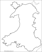 Wales: Outline Map Printout An outline map of Wales to print. |
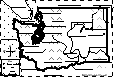
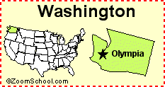 Washington State Washington is a state in the northwestern United States of America. Its capital is Olympia. Map, flag, symbols, printouts, and quizzes. |
 Washington State: Label Me! Label the major features of Washington state. Answers |
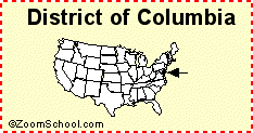 Washington, D.C. Washington, D.C., is the capital city of the United States of America. |
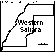 Western Sahara An outline map of Western Sahara to print. |
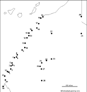 Western Sahara: Dot to Dot Mystery Map Connect the dots to draw the borders of a mystery country. Then use a globe or atlas to figure out which country you have drawn. You might want to give students clues, such as the continent the country is in (Africa), that it is in the Northern Hemisphere, or that its name starts with "W." Answer: Western Sahara. |
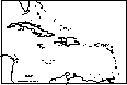 West Indies: Outline Map Printout An outline map of the Caribbean to print. |
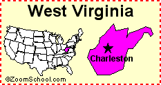 West Virginia West Virginia is a state in the eastern United States of America. Its capital is Charleston. Map, flag, symbols, printouts, and quizzes. |
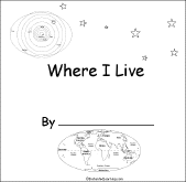
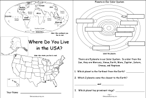 Where Do You Live in the USA A short activity book on geography to print for fluent readers; the student reads maps, draws maps, and answers questions abouts maps and direction. There are pages on the Solar System, the continents, North America, USA and the student's state. |
 Where I Live (Asia) A short activity book on geography to print for early readers. There are pages on the Solar System, the continents, Asia, and the student's home. |
 Where I Live (Australia) A short activity book on geography to print for early readers. There are pages on the Solar System, the continents, Australia (states and territories), and the student's address. |
 Where I Live (Europe) A short activity book on geography to print for early readers. There are pages on the Solar System, the continents, Europe, and the student's home. |
 Where I Live (UK) A short activity book on geography to print for early readers. There are pages on the Solar System, the continents, Europe, the UK, and the student's home. |
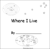
 Where I Live (USA and Canada) A short activity book on geography to print for early readers. There are pages on the Solar System, the continents, North America, and Canada or the USA. |
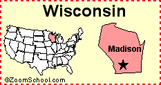 Wisconsin Wisconsin is a state in the United States of America. Its capital is Madison. Map, flag, symbols, printouts, and quizzes. |
 Word Bank of Country Names This is a word bank of country names. |
Word Bank of Geography Words This is a word bank of geography words. |
Word Bank of Landforms This is a word bank of landforms. |
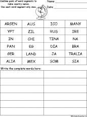 Word Pieces Puzzle: Country Names #1 In this puzzle, combine pairs of word segments to make country names. Words: Argentina, Australia, Brazil, China, Egypt, India, Japan, Germany, Ireland, Mexico, Russia, Somalia. Or go to the answers. |
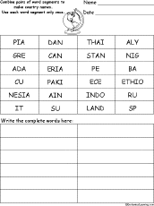 Word Pieces Puzzle: Country Names #2 In this puzzle, combine pairs of word segments to make country names. Words: Canada, Cuba, Ethiopia, Greece, Indonesia, Italy, Nigeria, Pakistan, Peru, Spain, Sudan, Thailand. Or go to the answers. |
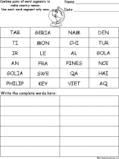 Word Pieces Puzzle: Country Names #3 In this puzzle, combine pairs of word segments to make country names. Words: Algeria, Angola, Chile, France, Haiti, Iraq, Mongolia, Philippines, Qatar, Sweden, Turkey, Vietnam. Or go to the answers. |
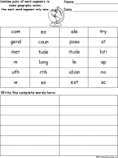 Word Pieces Puzzle: Geography In this puzzle, combine pairs of word segments to make geography-related spelling words. Words: compass, country, east, latitude, legend, longitude, meridian, map, north, scale, south, west. Or go to the answers. |
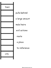 Geography Word Ladder Puzzle Worksheet On this printable worksheet, the student changes one word into another, one letter at a time. At each step along the way, change only one letter to make a new word. At the end, you have the final, related word. In this puzzle, morph the word town to the word city. Or go to the answers. |
World Capital Cities The capitals of all of the countries in the world, in alphabetical order by country. Or go to world capitals listed by continent. |
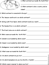 World Geography Quiz A Worksheet to Print A short, printable worksheet quiz about world geography. The short-answer worksheet asks 15 general questions about the earth's continents and oceans, for example, "On which continent do you live?" Or go to the answers. |
 World Flags A page on the flags of many countries. |
 World Map Label Me Printout Label the continents, oceans, poles, equator, and prime meridian. Answers |
World Map: Where I Live Label Me Printout Answer questions about where you live and label the world map. Answers |
 World: Map Quiz Printout Take a quiz on the map of the world. Or go to the answers. |
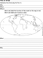 World News Article 5 W's Analysis Worksheet Summarize a world new article using this graphic organizer, noting the 5 w's, who, when, where, what, and why. Map the location of the news event and your location. |
 World: Outline Map Printout An outline map of the world to print (countries not marked). |
 World Latitude and Longitude: Outline Map Printout An outline map of world latitudes and longitudes to print. |
 World Latitude and Longitude (Cylindrical Projection): Outline Map Printout An outline map of world latitudes and longitudes to print (a cylindrical projection - it has straight lines of latitudes and longitude, but the areas near the poles are exaggerated in size). |
World Latitude and Longitude Activity (A Printout) Plot longitudes and latitudes on the world map. Or go to the answers. |
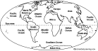
 World Political Outline Map Printout An outline map of the countries of the world to print. |
 World Rivers: Label Me! Printout Label the major rivers of the world. Or go to the answers |
 World Rivers: Outline Map Printout An outline map of the major rivers of the world to print. |
 Label the World in English Label the globe in English, including the North Pole, Arctic Circle, Northern Hemisphere, equator, Southern Hemisphere, and South Pole. Answers |
Label the World in French Label the globe in French, including the North Pole, Arctic Circle, Northern Hemisphere, equator, Southern Hemisphere, and South Pole. Answers |
Label the World in German Label the globe in German, including the North Pole, Arctic Circle, Northern Hemisphere, equator, Southern Hemisphere, and South Pole. Answers |
Label the World in Italian Label the globe in Italian, including the North Pole, Arctic Circle, Northern Hemisphere, equator, Southern Hemisphere, and South Pole. Answers |
Label the World in Spanish Label the globe in Spanish, including the North Pole, Arctic Circle, Northern Hemisphere, equator, Southern Hemisphere, and South Pole. Answers |
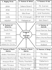 Write Geography Words by Category Write geography words by category (write 5 words per category). The categories include: Mapping Words, Features of Africa, Features of Asia, Features of Australia, Features of Europe, Features of North America, Features of South America, Features of Antarctica. Or go to sample answers. |
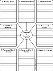 Write Geography Words by Category Write 10 geography words for each category. The categories include: Mapping Words, Features of Africa, Features of Asia, Features of Australia, Features of Europe, Features of North America, Features of South America, Features of Antarctica. Or go to sample answers. |
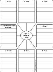 Write Bodies of Water by Category Write 5 bodies of water for each category. The categories include: Oceans, Seas, Lakes, Rivers, Gulfs, Bays, Straits, and Miscellaneous Bodies of Water. Or go to sample answers. |
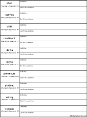 Write Landform-Related Definitions In this worksheet, write the definition of a word, what part of speech it is, and use it in a sentence. Words: atoll, canyon, cliff, continent, delta, mesa, peninsula, plateau, valley, volcano. Or go to the answers. Or go to a pdf of the questions and answers (subscribers only). |
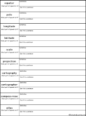 Write Map-Related Definitions In this worksheet, write the definition of a word, what part of speech it is, and use it in a sentence. Words: equator, pole, longitude, latitude, scale, projection, cartography, cartographer, compass rose, atlas. Or go to the answers. Or go to a pdf of the questions and answers (subscribers only). |
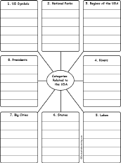 Write USA-Related Words by Category Write 5 USA-Related words for each category. The categories include: US Symbols, National Parks, Regions of the USA, Rivers, Lakes, States, Big Cities, Presidents. Or go to sample answers. |
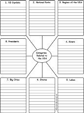 Write USA-Related Words by Category Write 10 USA-Related words for each category. The categories include: US Symbols, National Parks, Regions of the USA, Rivers, Lakes, States, Big Cities, Presidents. Or go to sample answers. |
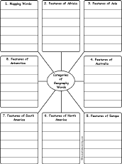 Write Geography Words by Category Write 5 geography words for each category. The categories include: Mapping Words, Features of Africa, Features of Asia, Features of Australia, Features of Europe, Features of North America, Features of South America, Features of Antarctica. Or go to sample answers. |
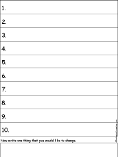 Write Ten Things About Your City A one-page printable worksheet. Write ten things about your city (plus one thing you would like to change). |
Write Ten Things About A Country A one-page printable worksheet. Write ten things about a country (plus one thing you would like to change). |
Write Ten Things About the Earth A one-page printable worksheet. Write ten things about the Earth (plus one thing you would like to change about it). |
Write Ten Things About Your Home A one-page printable worksheet. Write ten things about your home (plus one thing you would like to change). |
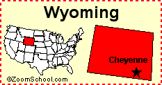 Wyoming Wyoming is a state in the western United States of America. Its capital is Cheyenne. Map, flag, symbols, printouts, and quizzes. |
| EnchantedLearning.com World Geography |
Flags |
| Africa | Antarctica | Asia | Australia/Oceania | Central America/ Caribbean | Europe | Mideast | North America | South America | USA |
| A | B | C | D | E | F | G | H | I | J | K | L | M | N | O | P | Q | R | S | T | U | V | W | X | Y | Z |
Enchanted Learning®
Over 35,000 Web Pages
Sample Pages for Prospective Subscribers, or click below
|
Overview of Site What's New Enchanted Learning Home Monthly Activity Calendar Books to Print Site Index K-3 Crafts K-3 Themes Little Explorers Picture dictionary PreK/K Activities Rebus Rhymes Stories Writing Cloze Activities Essay Topics Newspaper Writing Activities Parts of Speech Fiction The Test of Time
|
Biology Animal Printouts Biology Label Printouts Biomes Birds Butterflies Dinosaurs Food Chain Human Anatomy Mammals Plants Rainforests Sharks Whales Physical Sciences: K-12 Astronomy The Earth Geology Hurricanes Landforms Oceans Tsunami Volcano |
Languages Dutch French German Italian Japanese (Romaji) Portuguese Spanish Swedish Geography/History Explorers Flags Geography Inventors US History Other Topics Art and Artists Calendars College Finder Crafts Graphic Organizers Label Me! Printouts Math Music Word Wheels |
Click to read our Privacy Policy
| Search the Enchanted Learning website for: |