
|
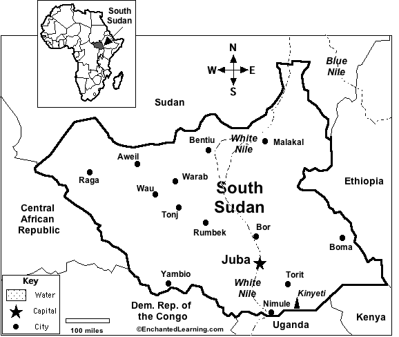
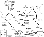
Capital: Juba is the capital of South Sudan.
Size: South Sudan covers about 644,329 square kilometers (slightly smaller than the state of Texas). South Sudan is the 42th largest country in the world.
Population: The people of South Sudan are called the South Sudanese. South Sudan has the 92nd largest population of any country in the world. The population of South Sudan is about 8,260,490 (as of July, 2010).
Government: South Sudan is a republic that is divided into 10 states (Central Equatoria, Eastern Equatoria, Jonglei, Lakes, Northern Bahr El Ghazal, Unity, Upper Nile, Warrap, Western Bahr El Ghazal, Western Equatoria). South Sudan became independent from Sudan on July 9, 2011.
Language: The official language is English. Other languages include Arabic (includes Juba and Sudanese variants) (official), regional languages include Dinka, Nuer, Bari, Zande, Shilluk.
Literacy Rate: About 27% (less than a third) of the adults in South Sudan can read and write. About 40% of the men and 16% of the women are literate.
Religion: Animist and Christian.
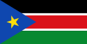
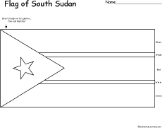
South Sudan's flag was adopted on July 9, 2011, when South Sudan became independent from Sudan.
Major Rivers: The White Nile flows through South Sudan.
Terrain/Mountain Ranges: South Sudan has highlands in the south.
Highest Point: The highest point in South Sudan is Kinyeti, which is 3,187 m above sea level; it is located in southern South Sudan along the border with Uganda.
Lowest Point: The lowest point in South Sudan is sea level.
Natural Resources: Hydropower, fertile agricultural land, gold, diamonds, petroleum, hardwoods, limestone, iron ore, copper, chromium ore, zinc, tungsten, mica, silver.
Major Industries: Industry in South Sudan is is generally underdeveloped.
Agricultural Products: Sorghum, maize, rice, millet, wheat, gum arabic, sugarcane, mangoes, papayas, bananas, sweet potatoes, sunflower, cotton, sesame, cassava, beans, peanuts; cattle, sheep.
South Sudan's FlagEnchantedLearning.com
All About South Sudan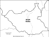
Map/Quiz Printout
Location: South Sudan (officially called the Republic of South Sudan) is a country in Africa. South Sudan is bordered by Sudan, Ethiopia, Kenya, Uganda, the Democratic Republic of the Congo, and the Central African Republic.
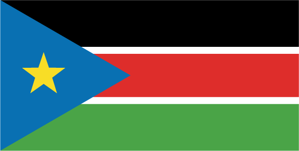 South Sudan's Flag: South Sudan's flag is a fimbriated tricolor (black, red and green)with a blue isosceles triange on the hoist side containing a golden yellow, five-pointed star. The color black represents the people of South Sudan, red symbolizes the blood shed in the struggle for freedom, green reflects the land, blue represents the waters of the River Nile, and the gold star represents the unity of the South Sudanese states.
Climate: South Sudan is hot with seasonal rainfall influenced by the annual shift of the Inter-Tropical Convergence Zone; rainfall is heaviest in the upland areas of the south and diminishes in the north.
Related Activities and Printouts:
South Sudan: Outline Map Printout An outline map of South Sudan to print. |
South Sudan Printable map worksheets that require research (using an atlas or other geography reference). Go to a simple map research activity, a medium-level map research activity, or an advanced map research activity. |
 South Sudan: Map Quiz Worksheet A printable quiz on the major geographic features of South Sudan. The student reads a map to answer 10 geography questions, for example: "If you traveled south from Juba, which country would you enter?" Or go to the answers. Or go to a pdf of the quiz and the answers |
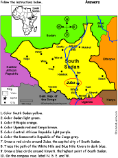 South Sudan: Follow the Instructions Draw and color South Sudan according to simple directions, such as, "Draw a red circle around Juba, the capital city of Sudan." Or go to the answers. |
 South Sudan: Flag Printout to Color |
 Sudan and South Sudan An outline map of Sudan and South Sudan to print. |
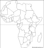
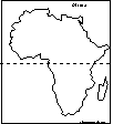 Africa: Outline Map Printout An outline map of Africa to print. |
 African Countries: Outline Map Printout An outline map of African countries to print. |
 African Countries Printout: Label Me! Label the countries of Africa. Answers |
 Africa: Zoom School Use a pictorial interface to get information on Africa. including maps, quizzes, animals, explorers, and printouts on Africa. |
Reference:
CIA World Factbook
Enchanted Learning®
Over 35,000 Web Pages
Sample Pages for Prospective Subscribers, or click below
|
Overview of Site What's New Enchanted Learning Home Monthly Activity Calendar Books to Print Site Index K-3 Crafts K-3 Themes Little Explorers Picture dictionary PreK/K Activities Rebus Rhymes Stories Writing Cloze Activities Essay Topics Newspaper Writing Activities Parts of Speech Fiction The Test of Time
|
Biology Animal Printouts Biology Label Printouts Biomes Birds Butterflies Dinosaurs Food Chain Human Anatomy Mammals Plants Rainforests Sharks Whales Physical Sciences: K-12 Astronomy The Earth Geology Hurricanes Landforms Oceans Tsunami Volcano |
Languages Dutch French German Italian Japanese (Romaji) Portuguese Spanish Swedish Geography/History Explorers Flags Geography Inventors US History Other Topics Art and Artists Calendars College Finder Crafts Graphic Organizers Label Me! Printouts Math Music Word Wheels |
Click to read our Privacy Policy
| Search the Enchanted Learning website for: |