
Rivers are flowing bodies of waters. There are rivers on every continent (except Antarctica).
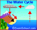
Rivers are flowing bodies of waters. There are rivers on every continent (except Antarctica). Rivers are an important part of the Earth’s water cycle and the sculpting of the Earth’s topography as they carry huge quantities of water from the land to the sea.
The Course of a River
Rivers generally start at a source, like a snow melt (such as a glacier) or a natural spring. Most rivers flow into a larger body of water, like an ocean, sea, or large lake.
 The early course of a river is often in steep, mountain areas, with rapidly-flowing cold water. As a river continues along its course (which is always changing), the surrounding terrain flattens out and the river widens. Rivers often meander (follow a winding path) along their middle course. Tributaries (smaller rivers or streams) and runoff flow into the river, increasing the river’s volume (the amount of water it has). Rivers often have increased volume and water speed in the spring, as snow at the river’s source melts.
 Most rivers end when they flow into a large body of water. The end of the river is called the mouth. At the mouth, there is usually a river delta, a large, silty area where the river splits into many different slow-flowing channels that have muddy banks. New land is created at deltas. Deltas are often triangular-shaped, hence the name (the Greek letter ‘delta’ is shaped like a triangle).
The Water in a River
At the source of a river, the water is relatively pure. As the water flows downstream, it picks up silt and minerals (including mineral salts) from the soil and rock in the river bed. Many other chemicals enter river water as it flows downstream, including animal waste, human sewage, agricultural (farm) runoff, urban runoff, and mining/factory effluent.
Erosion

An oxbow lake is a stagnant lake that is formed alongside a winding river when the river changes path because of soil erosion, leaving an abandoned stream channel, cut off from the rest of the river.
 The course of a river changes over time, as erosion caused by the flowing water and sediment sculpts the landscape around the river. Rivers erode land and carry it downstream towards the sea or lake it flows into. This kind of erosion can even form canyons, like the Grand Canyon (eroded by the Colorado River), waterfalls, like Victoria Falls (formed by the Zambezi River), oxbow lakes, and other formations.
As eroded soil is carried downstream, it is deposited at areas where the river slows, especially where the river meets the body of water it flows into (often the ocean or a lake), forming a fertile river delta that has muddy swamps and/or sandbars.
Estuaries
 An estuary is the area where a river meets the sea or ocean, where fresh water from the river meets salt water from the sea. Estuaries are often called bays, sounds, or harbors (like Tampa Bay, Puget Sound, or Boston Harbor). Salt marshes are low, grassy, coastal areas surrounding an estuary; the tides often overflow the marsh.
Since salt water is heavier (denser) than fresh water, when the two meet, the heavier salt water sinks and the lighter fresh water rises. The rate of change in salinity (the amount of salt in the water) with depth is called the salinity gradient.
Estuaries are transitional areas between rivers and seas, and are home to many organisms that have adapted to life in brackish water (water that is saltier than river water but less salty than sea water).
Animals and Plants
Rivers provide a home, drinking water, and/or a hunting ground for many organisms.
Rivers and People
Rivers provide drinking water, irrigation water, transportation, hydro-electrical power, drainage, food, and recreation opportunities.
River Extremes
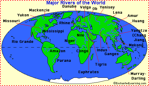
 The longest river in the world is the Nile River (4,157 miles long); it is located in northeastern Africa, and flows into the Mediterranean Sea. The second-longest river is the Amazon River (3,915 miles long); it is located in northeastern South America, and flows into the Atlantic Ocean. The third-longest river is the Chang (Yangtse) River (3,434 miles long); it flows across south-central China into the East China Sea.
The river with the biggest volume (the most water flowing in it) is the Amazon River.
| Continent | Longest River | Length |
|---|---|---|
| Africa | Nile River | 4,157 miles (6,690 km) long |
| Antarctica | none | n/a |
| Asia | Yangtze River | 3,434 miles (5,530 km) long |
| Australia | Murray-Darling River | 2,310 miles (3,720 km) long |
| Europe | Volga River | 2,290 miles (3,700 km) long |
| North America | Mississippi-Missouri River | 2,540 miles (4,090 km) + 2,340 miles (3,770 km) long |
| South America | Amazon River | 3,915 miles (6,300 km) long |
Related Activities
Read about rivers then answer some questions in this worksheet.
Label the major rivers of the world in this printable worksheet.
A printable outline map of the major rivers of the world.