
|
| You might also like: | Major Tsunamis | Tsunami Warning Printout | Tsunami Quiz Printout | WHALE SHARK - Zoom Sharks | Tornado Classification, F-Scale | Today's featured page: Bacteria |
 |
Tsunami |
|
||
| Tsunami Information | Major Tsunamis | Tsunami Glossary | Tsunami Activities and Printouts |
 active volcano An active volcano is one that has erupted in recorded history or is currently erupting. |
aftershock Aftershocks are small earthquakes that occur after a large earthquake. |
avalanche An avalanche is a a large mass of falling and/or sliding material. Avalanches can be composed of rock, snow, soil, or ice. Volcanic eruptions can cause avalanches. |
bathypelagic Bathypelagic means of, pertaining to, or living in the deep ocean near the bottom. |
| buoy A buoy is a floating device that is tethered to the sea floor. Buoys can mark an offshore location, warn of danger, or show a ship where a navigable channel is. |
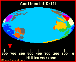 continental drift Continental drift is the movement of the Earth's continents. The land masses are hunks of Earth's crust that float on the molten core. The ideas of continental drift and the existence of a supercontinent (Pangaea) were presented by Alfred Wegener in 1915. |
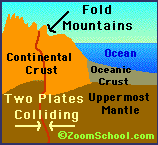 continental plates The crust of the Earth is broken into plates. The plates are enormous chunks of rock that float atop the soft mantle. The plates are moving at a speed that has been estimated at 1 to 10 cm per year. Continental plates are thicker, older, and less dense than oceanic plates. These plates are about 125 kilometers thick and are made of granite that is about 3 billion years old. |
continental shelf The continental shelf is the part of the ocean floor next to each of the continents. The sea floor slopes gradually from the continent to a depth of about 650 feet (200 m). Beyond the continental shelf the sea floor drops steeply. |
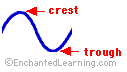 crest The crest of a wave is its highest point. |
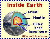 crust The Earth's crust is its outermost, rocky layer. |
current A current is a non-periodic horizontal movement of water. Currents are caused by winds, temperature differentials, and other forces. They are NOT caused by tidal forces (the gravitational forces of the Moon and Sun). Some major currents include the Gulf Stream in the Atlantic Ocean and the Humboldt Current in the Pacific Ocean. |
debris avalanche A debris avalanche is a sudden rock/soil/debris slide and flows with great speed from a volcano. |
| drawback Drawback is a phenomenon in which the ocean recedes before a tsunami strikes a coast. |
earthquake An earthquake is a sudden, violent movement of the earth's crust. |
epicenter The epicenter is the point on the Earth's surface directly above the place that an earthquake occured. |
eruption An eruption is volcanic activity in which lava, tephra, or gases are released. |
frequency The frequency of a wave is the number of times that a wave is produced within a time period. |
guyot A guyot is a flat-topped, undersea mountain (a seamount) formed from a volcano. |
hotspot A hot spot is a an area in the Earth's lithosphere through which magma (molten rock) rises. Volcanoes often erupt over hot spots. |
Krakatoa Krakatoa is a composite volcano located in Indonesia. On August 26, 1883 Krakatoa erupted violently, destroying most of the volcano and killing thousands of people. This was one of the biggest volcanic eruptions in modern times. |
K-T extinction The K-T extinction was the mass extinction that occurred 65 million years ago, at the boundary of the Cretaceous and Tertiary periods. |
lahar A lahar (also called a mudflow or debris flow) is a moving mixture of rock, water, and other debris that falls down the slopes of a volcano and/or a river valley. Lahar is an Indonesian word |
lava Lava is molten rock. It usually comes out of erupting volcanoes. |
magnitude The intensity of an earthquake is described by a number in the Richter scale, called the magnitude. The magnitude of an earthquake is calculated from the logarithm of the amplitude of waves recorded by seismographs. A magnitude 2.0 or less earthquake is called a microearthquake and is not felt by people. A magnitude 4.5 or more earthquake can be measured by seismographs all over the world. Tsunamis can be caused by undersea earthquakes of magnitude 7.5 or greater. |
maremoto Maremoto is the Spanish word for tsunami. |
meteor A meteor is a meteoroid that has entered the Earth's atmosphere, usually making a fiery trail as it falls. It is sometimes called a shooting star. Most burn up before hitting the Earth. |
meteorite A meteorite is a meteor that has fallen to Earth. Meteorites are either stone, iron, or stony-iron. |
meteoroid Meteoroids are tiny stones or pieces of metal that travel through space. |
| neretic Pertaining to the shallow waters near the shore over the continental shelf. |
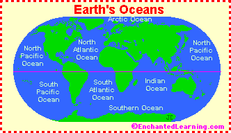 ocean An ocean is a vast body of salt water. Oceans cover more than three-quarters of the surface of the Earth. The oceans on Earth include the Pacific Ocean, the Atlantic Ocean, the Indian Ocean, and the Arctic Ocean. The ocean floors are composed mostly of basalt. |
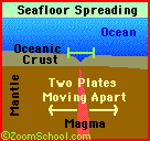 oceanic plates The crust of the Earth is broken into plates. The plates are enormous chunks of rock that float atop the soft mantle. The plates are moving at a speed that has been estimated at 1 to 10 cm per year. Oceanic plates (those that are under the ocean) are thinner, younger, and denser than continental plates. These underwater plates are about 75 kilometers thick and are made of basalt rock. They are relatively young since plate formation (seafloor spreading) occurs at the margins of oceanic plates. |
oceanographer A oceanographer is a scientist who studies oceans. |
period Period is the time between two successive waves. |
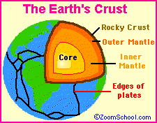 plates The crust of the Earth is broken into plates. The plates are enormous chunks of rock that float atop the soft mantle. The plates are moving at a speed that has been estimated at 1 to 10 cm per year. Oceanic plates (those that are under the ocean) are thinner and denser than continental plates. |
plate tectonics Plate tectonics is the now-established theory that chunks of the Earth's crust (plates) float on the surface and change both position and size over time. |
raz-de-marée Raz-de-marée is the French word for tsunami. |
Richter, Charles F. Charles Francis Richter (April 26, 1900- April 30, 1985) was a who developed the Richter scale, a logarithmic scale that measures the intensity of an earthquake. He developed it in 1935 at the California Institute of Technology. |
Richter scale The Richter scale is a logarithmic scale that measures the intensity of an earthquake. It was developed in 1935 by Charles F. Richter. The magnitude of an earthquake is calculated from the logarithm of the amplitude of waves recorded by seismographs. Beno Gutenberg also contributed to the more general application of the Richter scale. A magnitude 2.0 or less earthquake is called a microearthquake and is not felt by people. A magnitude 4.5 or more earthquake can be measured by seismographs all over the world. |
rift A rift (or graben) is a valley between two faults. |
 ring of fire The ring of fire is an area around the Pacific Ocean that is high in volcanic, mountain-building, and seismic activity. |
rock A rock is an aggregation of solid matter, a random conglomerate of minerals. The earth's crust is made of rock. There are three types of rock: igneous, sedimentary, and metamorphic. Petrology is the scientific study of rocks. |
rock cycle The rock cycle decribes the relationship between igneous, sedimentary, and metamorphic rocks. James Hutton (1727-1797) first developed the concept of the rock cycle. |
runoff Runoff is water (or other liquids) that drains or flows from the land into streams and rivers, and eventually into the seas. The water is generally from rain or snowpack melt. |
runup Runup is the height of the water pushed onshore (above normal sea level) after a tsunami. |
seismograph A seismograph is a device that records and measures seismic waves (vibrations in the Earth), like those from earthquakes. |
spreading ridge A spreading ridge is an area of the ocean floor in which new crust is being formed as magma erupts. |
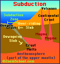 subduction A subduction is a phenomenon in which one part of the Earth's crust (a plate) is pushed underneath another plate as two plates collide. The descending crust melts as it is pushed deep into the Earth's mantle. Subduction destroys crust and recycles it back into the mantle. |
subduction zone A subduction zone is an area on a planet's crust in which the edge of an oceanic continental plate is being pushed beneath another plate. |
tectonic activity Tectonic activity is the shifting of a planet's surface because of changes deep inside the body. Earthquakes, fissures, rifts, and volcanoes are some results of tectonic activity. |
tidal wave Tidal wave is an incorrect term that refers to a tsunami. |
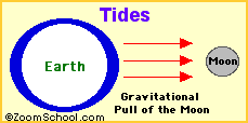 tide A tide is a periodic rise and fall of large bodies of water. Tides are caused by the gravitational interaction between the Earth and the Moon. The gravitational attraction of the moon causes the oceans to bulge out in the direction of the moon. Another bulge occurs on the opposite side, since the Earth is also being pulled toward the moon (and away from the water on the far side). Since the earth is rotating while this is happening, two tides occur each day. Isaac Newton was the first person to explain tides scientifically. |
trough The trough of a wave is its lowest point. |
tsunami A tsunami (also called a seismic sea wave) is a huge wave, caused by undersea earthquakes, volcanic eruptions, or, more rarely, by asteroid or meteoroid impact (as in the case of the K-T extinction). |
volcanic seamount A volcanic seamount is an underwater volcano that rises at least 50-100 m above the sea floor. Some seamounts rise above the water's surface. |
volcano A volcano is a place on the Earth's surface (or any other planet's or moon's surface) where molten rock, gases and pyroclastic debris erupt through the earth's crust. Volcanoes vary quite a bit in their structure - some are cracks in the earth's crust where lava erupts, and some are domes, shields, or mountain-like structures with a crater at the summit. Some types of volcanoes include: caldera, cinder cone, hornito, lava dome, maar, mud volcano, shield volcano, spatter cone, and stratovolcano. The word volcano is from Latin; it comes from the ancient Romans god of fire and metalworking, Vulcan. |
wave Most waves are caused by the wind. Tsunami waves are caused by the undersea displacement of a huge volume of water caused by an earthquake, volcano, rock slide, etc. |
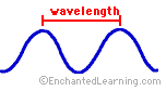 wavelength The wavelength of a waves is the distance from crest to crest or from trough to trough. |
vulcanologist A vulcanologist is a scientist who studies volcanoes. |
| EnchantedLearning.com ALL ABOUT OCEANS AND SEAS |
|
Enchanted Learning®
Over 35,000 Web Pages
Sample Pages for Prospective Subscribers, or click below
|
Overview of Site What's New Enchanted Learning Home Monthly Activity Calendar Books to Print Site Index K-3 Crafts K-3 Themes Little Explorers Picture dictionary PreK/K Activities Rebus Rhymes Stories Writing Cloze Activities Essay Topics Newspaper Writing Activities Parts of Speech Fiction The Test of Time
|
Biology Animal Printouts Biology Label Printouts Biomes Birds Butterflies Dinosaurs Food Chain Human Anatomy Mammals Plants Rainforests Sharks Whales Physical Sciences: K-12 Astronomy The Earth Geology Hurricanes Landforms Oceans Tsunami Volcano |
Languages Dutch French German Italian Japanese (Romaji) Portuguese Spanish Swedish Geography/History Explorers Flags Geography Inventors US History Other Topics Art and Artists Calendars College Finder Crafts Graphic Organizers Label Me! Printouts Math Music Word Wheels |
Click to read our Privacy Policy
| Search the Enchanted Learning website for: |