
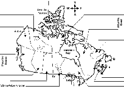
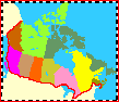
Canada has 10 provinces and 3 territories: Alberta (Edmonton), British Columbia (Victoria), (Fredericton), Nova Scotia (Halifax); Nunavut (Iqaluit), Ontario (Toronto), Quebec (Quebec City), Saskatchewan (Regina), Newfoundland (St. John's), Northwest Territories (Yellowknife), and YukonTerritory (Whitehorse).
Canada
 Canada is a huge country in the continent of North America. Canada is comprised of 3,849,675 square miles (9,976,140 square km); it is the second-largest country in the world (Russia is first at 17,075,200 sq km). This huge country borders the Atlantic Ocean, the Pacific Ocean, the Arctic Ocean, and the United States of America. Canada has over 151,480 miles (243,791 km) of coastline. Most of Canada’s human population lives along its southern border. For a page on Canadian explorers, cick here.
The Capital
The capital of Canada is the city of Ottawa, which is in the province of Ontario, located above the Great Lakes.
Provinces and Territories
Canada has 10 provinces and 3 territories (the capital of each is shown in parentheses): Alberta (Edmonton), British Columbia (Victoria), Prince Edward Island (Charlottetown), Manitoba (Winnipeg), New Brunswick (Fredericton), Nova Scotia (Halifax), Nunavut (Iqaluit), Ontario (Toronto), Quebec (Quebec City), Saskatchewan (Regina); Newfoundland and Labrador (St. John’s), Northwest Territories (Yellowknife), and Yukon Territory (Whitehorse).
Geography
Canada’s land ranges from fertile agricultural plains in the south to freezing tundra in the north. The southwest of Canada (British Columbia) has a mild climate. Cold winters characterize most of the rest of Canada. The magnetic North Pole is within Nunavut.
Mountains
Parts of Canada are very mountainous. The tallest mountain in Canada is the Yukon’s Mount Logan, which is 19,850 feet (6050 m) tall. Canada has many mountain ranges, including the Appalachians, Torngats, and Laurentians in the eastern regions, the Rocky, Coastal, and Mackenzie ranges in the western regions, and Mount St. Elias and the Pelly Mountains in the northern country.
Lakes
Canada has about two million lakes. The biggest lakes are (in order by their surface area): Lake Huron [36,000 sq. km of Lake Huron’s 59,600 sq. km are in Canada], Lake Great Bear [31,328 sq. km], Lake Superior [of which 28,700 sq. km of Lake Superior’s 82,100 sq. km are in Canada], Lake Great Slave [also the deepest lake, with a depth of 614 m], Lake Winnipeg, Lake Erie and Lake Ontario. The 2,000,000 lakes cover about 7.6% of Canada’s land.
Rivers
The longest river in Canada is the Mackenzie River, which is 2,635 miles (4241 km) long. It runs through the Northwest Territories. Other large and important rivers are the St. Lawrence River (1,900 miles = 3058 km long), the Yukon River, the Columbia River (partly in the USA), the Nelson River, the Churchill River, and the Fraser River.

Zoom School is an on-line elementary-school classroom. Subject links include geography, science activities, stories, history, crafts, animals, art, time information, and games, and relate to the theme.
Canada - Follow the Instructions: A printout about Canada and maps for young readers.
Label Canadian Provinces Map Printout.
Outline Map Canada: A collection of geography pages, printouts, and activities for students.
Canadian Map. Canada has 10 provinces and 3 territories: Alberta (Edmonton), British Columbia (Victoria), (Fredericton), Nova Scotia (Halifax); Nunavut (Iqaluit), Ontario (Toronto), Quebec (Quebec City), Saskatchewan (Regina), Newfoundland (St. John’s), Northwest Territories (Yellowknife), and YukonTerritory (Whitehorse).

Canadian Flags. The flag of Canada and the Canadian provincial flags.

Canadian Province/Territory Report Diagram Printout #2: Thiss chart is used to write a short Canadian province/territory report, including a hand-drawn map and flag, capital city, area, population, etc.

Canadian Province/Territory Report Diagram Printout: Thiss chart is used to write a short Canadian province/territory report, including a hand-drawn map and flag, capital city, area, population, etc.
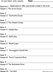
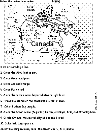
In this worksheet, the student is given a series of short answers using Canadian geography words to make questions for.
A list of explorers of Canada with brief descriptions.
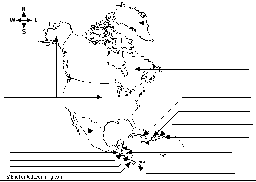
Label North America Printout.
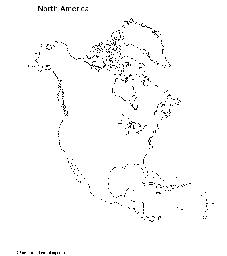
Outline Map North America: A collection of geography pages, printouts, and activities for students.

This is a short, printable book about Canadian animals for early readers.
This is a short activity book on geography to print for early readers.
Canadian Crafts for kids. Kindergarten, preschool, and elementary school crafts. Make wonderful, simple crafts with things found around the house.
Dinosaur Fossil Locations: Canada. See where dinosaurs fossils have been found around in Canada.